


Whales, myths, and Arctic lakes: Explore Iceland’s new road trip
by Amelia Duggan
January 21st, 2021
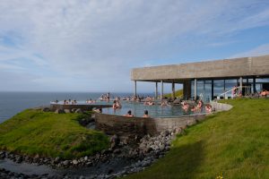
 Geosea Geothermal Sea Baths, Húsavík. Credit: Amelia Duggan
An epic drive across the Nordic nation’s less-touristed north reveals breathtaking nature and historic battles on land and sea
Published online at nationalgeographic.com
Iceland is filled with rugged nature and swirling stories—history, legends, and folklore that cover this land as thickly as its winter snows. Until recently, most travelers searched for the island nation’s cultural and natural charms along the Ring Road, the famed 828-mile highway circumnavigating the country. In normal times, Iceland’s most famous highway comes with big thrills—huffing volcanos, exploding geysers—but it also comes with swarms of tourists.
Not so the recently launched Arctic Coast Way. Created in 2019, it links existing auto routes in Iceland’s rugged north into one epic road trip. For now, it’s still a less-traveled gem of otherworldly basalt cliffs, pebble beaches with basking seals, and utter solitude.
From May to September, you can rent a car and spend several days traversing the 560-mile route of dirt and paved roads. Winter trips are also possible, but may be impacted by snowfall and other weather-related detours.
The Arctic Coast Way starts in the village of Hvammstangi and follows the filigreed coastline of seven peninsulas—each with their own geological marvels, stories, and wildlife—ending in the hamlet of Bakkafjörður. Signposts mark the way: a white infinity symbol over a sketched outline of Icelandic territory. Here are some of the drive’s highlights, from whale watching to a Nordic spin on Stonehenge. Most places are open; call ahead to check about COVID-19 related closures.
Off-the-beaten-track beauty and historic battles
Tourism has yet to gain a foothold in these parts, and a four-wheel-drive is obligatory for tackling the gravel tracks. Hvammstangi may be only a half-day’s drive from Reykjavík, but these lonely shores feel a million miles from the capital and the south’s popular geological hotspots.
“The north won’t change; it’ll never be Reykjavík,” says Dagný Marín Sigmarsdóttir, the proprietor of the Museum of Prophecies in the village of Skagaströnd, about 50 miles northeast of Hvammstangi. The museum explores the history of a legendary 10th-century fortune teller, and Sigmarsdóttir herself can read your palm. “We’d love more travelers to come this way to share the beauty,” she says.
You’ll hear a similar message in Sauðárkrókur. Drive around the first two peninsulas—Vatnsnes and Skagi—to reach this picturesque port town on the dramatic Skaga Fjord. Compared to many settlements on the Arctic Coast Way, it’s positively cosmopolitan: there’s a pub open late and a restaurant serving northern delicacies including cured foal and smoked sheep.
Hótel Tindastóll is Iceland’s oldest hotel, with narrow staircases, crooked ceiling beams, and fireside seats with fur throws. Framed photos of one-time guest Marlene Dietrich add glamour to some rooms.
Áskell Heiðar Ásgeirson wants more visitors to pause in his hometown. “Travelers pass by Sauðárkrókur on the Ring Road, or they stop quickly for lunch. We’d love them to linger here—to spend a night at least.”
That’s why Ásgeirson created 1238: The Battle of Iceland, an interactive exhibit using jazzy virtual- and augmented-reality technology to place you in the country’s action-packed Sturlung Era. “There were so many killings and betrayals within the family clans; it’s a real-life Game of Thrones,” he says.
The eponymous 13th-century battle, perhaps the most famous in Icelandic history, happened not far from the exhibit, and the carnage resulted in the island ceding its independence to the Norwegian crown. Iceland wouldn’t become sovereign again until 1944.
Ásgeirson equips guests with virtual-reality goggles, gloves, and vests before plugging them into the past where they’ll “fight” alongside legendary clan leader Sturla Sighvatsson using virtual rocks and spears. “We may not have the biggest waterfalls here or the most dramatic glaciers, but we have our stories,” he says. “That’s our great treasure.”
A coastal ghost town reborn
The elemental beauty of the next peninsula, Tröllaskagi, proves a driving hazard. Twists in the road reveal vistas so vast and breathtaking they’re distracting. The Arctic Coast Way goes on through arcadian valleys of patchwork pastures and wind-raked lakes, up into blustery highlands with views across the ocean. Here, the mossy rocks appear so square and stacked, they could be the ruins of a citadel.
At the very tip of the land, accessed by a series of narrow mountain tunnels, stands the fishing port of Siglufjörður. Nicknamed Sigló, it’s an up-and-coming weekend getaway. Summer homes with old-fashioned pitched roofs creep up the foothills and overlook the fjord, and the working dock is flanked by two stylish restaurants and a boutique hotel.
Elsewhere, a former fish factory has been converted into a craft brewery, Segull 67, and murals decorate side streets. It’s postcard pretty now, but a few decades ago, before recent investment, Sigló was a ghost town, emptied out after the once-thriving herring fishing here dried up in the 1960s.
“After 1969, no one returned. The town just rotted,” says tour guide Edda Björk Jónsdóttir. She leads visitors around the Herring Era Museum, which dives into maritime history in Iceland. “We renovated these waterfront houses and collected these artifacts to capture the human stories of an incredible period in our history,” she says.
Herring fishing in Sigló began in the early 1900s. The fjord was home to just a handful of rustic turf houses at the time, but a port and a town sprung up to serve the lucrative new industry. At its peak, Sigló was home to 12,000 workers in the summers. “There was a high street with a cinema and candy factory, and fashionable dances. Men and women people came from all over Iceland to make their fortune,” says Jónsdóttir. “Then, as quickly as it started, it all ended. They’d overfished the herring.”
By the end of the 1960s, there was nothing left to catch. This led to the Cod Wars of the 1970s, in which Icelandic fishermen clashed with British trawlers as they looked further afield to fill their nets.
Whales and waves near the Arctic Circle
Getting out onto the water offers further insights into Iceland’s marine ecosystems. Onboard a traditional wooden schooner from the cozy town of Húsavík, you can go north across the Skjálfandi, meaning “shaky bay.”
A humpback whale surfaces near a whale-watching boat
harbor town of Husavik, a whale-watching center in Iceland
Left: A humpback whale surfaces near a wildlife-watching boat off the north coast of Iceland.
Most people think the name comes from the swell of the water, but it’s actually because the area is prone to earthquakes. The town’s chocolate-box church, clifftop geothermal pools, and riding stables fade to a whitish smudge as the schooner gets farther from shore. The bay is flanked by mountains. Up ahead—just 30 miles north, beyond the gaping mouth of Shaky Bay—lies the Arctic Circle.
Húsavík bills itself as “the whale-watching capital of Europe,” so passengers keep a lookout for telltale signs: a splash, a spurt or a tail, or a flock of gulls circling above the waves. Eleven species visit the area to feed, including the planet’s largest animal: the blue whale. You also might spot harbor porpoises and sea birds such as puffins and razorbills.
Still, Iceland is one of just three countries in the world allowing whale hunting in its waters—a surprising blight on an otherwise largely progressive political agenda. “In Húsavík, at least, there’s no question about it: whales aren’t on the menu,” says marine biologist Christian Schmidt, who works for North Sailing, the oldest whale-watching outfit in Húsavík. “Nor puffins. My feeling is that it’s only offered for tourists; no one in Iceland wants this anymore. Maybe if tourists refused to try it, we could make a change.”
Inland lakes and steamy baths
It’s also worth taking an inland detour from the quiet majesty of the Arctic Coast Way to visit one of the region’s show-stopping attractions: Mývatn. The tranquility of this lake and the bird-filled wetland surrounding it belies the seething, subterranean forces at work here. The 14-square-mile lake rests on top of the Mid-Atlantic Ridge—the meeting point of the North American and Eurasian tectonic plates.
Circle the lake, and you’ll pass bird nesting grounds and scattered islands on the way to its eastern shore. There, you’ll find an embarrassment of geological curiosities—and, maybe, other travelers. Hverfjall, a towering crater, dominates a landscape of belching mud pots, sulphurous fumaroles, sunken pseudocraters, and sculptural lava fields. Hike through this wonderland for insights into the violent forces lurking at the planet’s core.
The area also holds Mývatn Nature Baths, the North’s answer to Rejkjavík’s perennially busy Blue Lagoon. Soaking in a “hot pot” is a national pastime. Recommended accessories include a crisp, freshly pulled pint of lager from the bar and a woolly hat.
The milky water is gloriously hot. The thing to do is to find a ledge—silky with built-up mineral deposits—and watch the wind whip at the rising steam, causing the sweeping landscape to shift in and out of sight.
In the far north, elves and amazing views
It’s a spectacular half-day’s drive from the Mývatn region back to the Arctic Coast Way with its unpaved roads, weather-beaten lighthouses, and iridescent ocean.
On the way to the sparsely populated peninsulas of the northeast are two welcome pit stops: Europe’s most powerful waterfall, Dettifoss, where rainbows arc through the almighty spray, and the canyon of Ásbyrgi, with its forested hiking trails and emerald-hued lake.
According to early myths, the horseshoe-shaped gully was created by the hoof of Oðin’s (aka the Norse god Odin) huge, eight-legged steed. Ásbyrgi later became considered the capital of the Huldufólk—the hidden people, or elves. Legends say they look much like humans, only taller, more beautiful, and clad in fine gowns.
A handful of people call Melrakkaslétta home—most concentrated in or around the village of Raufarhöfn. It’s a place few travelers venture to. But that hasn’t stopped the locals from dreaming up an ambitious hilltop attraction: a monumental sundial built in the image of Stonehenge.
Right now, it’s only half-finished, but already there are five rough-hewn portals that frame the landscape and evoke the country’s pagan roots. When completed, it’s hoped the Arctic Henge will be a site of pilgrimage for aurora chasers, and host festivals on the solstices.
Its final architecture will also speak to Norse mythology surrounding the cosmos’s birth and death as set out in the medieval poem Völuspá.
The north, it seems, is forever finding new and spectacular ways to tell its ancient tales.